This site will not be available after March 31, 2021. Learn more
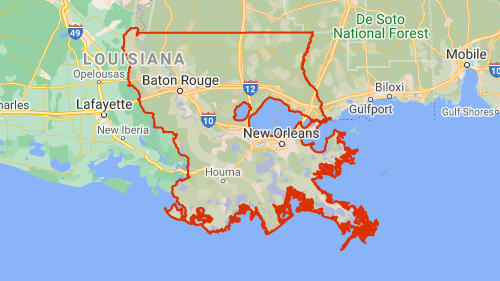
Flash Flood Watch in Southeastern Louisiana
Related News
Flash flood watch up for Southeastern Louisiana; heavy rains set to hit area this week
The Advocate ·
The storminess is the result of a cold front that will move slowly through the area, beginning Tuesday, which is expected to stall over southeast Louisiana and coastal Mississippi, remaining over the area before lifting north on Thursday. That's when cooler, and ...
Ohio, Big Muddy, Mississippi rivers floodingin region
Annanews ·
Flooding continued during the past week on rivers in the region as the result of additional heavy rainfall. Floodwarnings remained in effect for the Ohio River and the Big Muddy River in Southern Illinois. The Mississippi River also was on the rise in Southern ...
Louisiana Spotlight: Flood of federal cash transforms state budget situation
The Advocate ·
Only months after concerns the coronavirus pandemic would force hefty budget cuts, Louisiana instead is awash in cash, billions of dollars in federal COVID-19 aid passed by Democrats in Congress. Those billions — including nearly $3.4 billion in direct ...
Tips from ready.gov
Before:
- Build an emergency kit and make a family communications plan.
- Elevate the furnace, water heater and electric panel in your home if you live in an area that has a high flood risk.
- Consider installing "check valves" to prevent flood water from backing up into the drains of your home.
- If feasible, construct barriers to stop floodwater from entering the building and seal walls in basements with waterproofing compounds.
- More:
- What to do before a flood.
During:
- Be aware that flash flooding can occur. If there is any possibility of a flash flood, move immediately to higher ground. Do not wait for instructions to move.
- If you must prepare to evacuate, you should do the following:
- Turn off utilities at the main switches or valves if instructed to do so. Disconnect electrical appliances. Do not touch electrical equipment if you are wet or standing in water.
- Secure your home. If you have time, bring in outdoor furniture. Move essential items to an upper floor.
- Be aware of stream, drainage channels, canyons and other areas known to flood suddenly. Flash floods can occur in these areas with or without typical warnings such as rain clouds or heavy rain.
- If you have to leave your home, remember these evacuation tips:
- Do not walk through moving water. Six inches of moving water can make you fall. If you have to walk in water, walk where the water is not moving. Use a stick to check the firmness of the ground in front of you.
- Do not drive into flooded areas. If floodwaters rise around your car, abandon the car and move to higher ground if you can do so safely. You and the vehicle can be swept away quickly.
- Do not camp or park your vehicle along streams, rivers or creeks, particularly during threatening conditions.
- More:
- What to do during a flood.
Other alerts in this area
Flash Flood Watch in Mississippi
National Weather Service · Posted 4 hours ago


