Tropical system approaches, most significant impacts stay east
Tropical system approaches, most significant impacts stay east
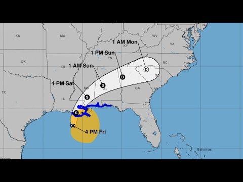
BATON ROUGE, La. (WAFB) - The National Hurricane Center is still forecasting the Gulf system to become Claudette before making landfall tonight along the Louisiana coast. However, the system remains poorly organized and lopsided into Friday afternoon, resulting in slower-than-anticipated intensification.
The forecast track has also continued to be nudged eastward and that means a continued reduction in threats for most WAFB neighborhoods. In addition, the steady forward speed that has developed should get the core of the system out of our area relatively quickly on Saturday, reducing the time window for significant impacts.
At 10 p.m., the NHC reported Potential Tropical Cyclone 3 was located at 28.9 North, 90.0 West, or about 60 miles south-southeast of Morgan City, La. The maximum sustained winds were 45 mph and it was moving north at 13 mph.
Occasional tropical-storm-force wind gusts cannot be ruled out between Friday night and Saturday mid-day but sustained tropical-storm-force winds are likely to be confined to the coastal and southeasternmost parishes. And with the eastward shift in the track, if not all, of the WAFB region can expect rain totals of 3″ inches or less. That said, we will need to closely watch rainband activity: those bands will be capable of producing localized heavy downpours, localized damaging thunderstorm wind gusts, and even an isolated tropical tornado or two, especially for areas south and east of metro Baton Rouge.
In the end, the overall impacts for the WAFB region will be substantially less than what the Storm Team had feared just two or three days ago. While the main severe weather threats should end by or before Saturday afternoon, rains will linger into Saturday evening, Saturday night, and into Father’s Day Sunday.
Click here to report a typo.
Copyright 2021 WAFB. All rights reserved.
Read more > https://www.wafb.com/2021/06/18/tropical-system-approaches-most-significant-impacts-stay-east/

