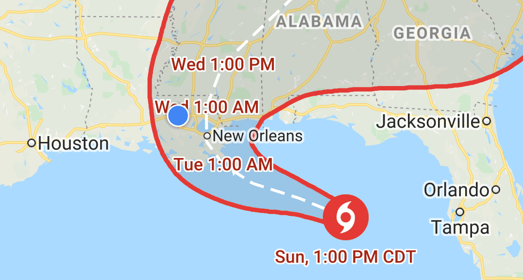

Hurricane Warningfor Livingston Parish, Louisiana
Active for next 7 hours
Posted 1 hour ago
...HURRICANE WARNING REMAINS IN EFFECT...
...STORM SURGE WARNING REMAINS IN EFFECT...
* LOCATIONS AFFECTED
- Denham Springs
- Walker
* WIND
- LATEST LOCAL FORECAST: Equivalent Tropical Storm force wind
- Peak Wind Forecast: 40-50 mph with gusts to 65 mph
- Window for Tropical Storm force winds: Monday evening until
early Wednesday morning
- THREAT TO LIFE AND PROPERTY THAT INCLUDES TYPICAL FORECAST
UNCERTAINTY IN TRACK, SIZE AND INTENSITY: Potential for wind 74
to 110 mph
- The wind threat has remained nearly steady from the
previous assessment.
- PLAN: Plan for life-threatening wind of equivalent CAT 1 or
2 hurricane force.
- PREPARE: Remaining efforts to protect life and property
should be urgently completed. Prepare for considerable wind
damage.
- ACT: Move to safe shelter before the wind becomes hazardous.
- POTENTIAL IMPACTS: Extensive
- Considerable roof damage to sturdy buildings, with some
having window, door, and garage door failures leading to
structural damage. Mobile homes severely damaged, with some
destroyed. Damage accentuated by airborne projectiles.
Locations may be uninhabitable for weeks.
- Many large trees snapped or uprooted along with fences and
roadway signs blown over.
- Some roads impassable from large debris, and more within
urban or heavily wooded places. Several bridges, causeways,
and access routes impassable.
- Large areas with power and communications outages.
* STORM SURGE
- LATEST LOCAL FORECAST: Localized storm surge possible
- Peak Storm Surge Inundation: The potential for up to 2 feet
above ground somewhere within surge prone areas
- Window of concern: Begins early Wednesday morning
- THREAT TO LIFE AND PROPERTY THAT INCLUDES TYPICAL FORECAST
UNCERTAINTY IN TRACK, SIZE AND INTENSITY: Potential for storm
surge flooding greater than 1 foot above ground
- The storm surge threat has remained nearly steady from the
previous assessment.
- PLAN: Plan for storm surge flooding greater than 1 foot
above ground.
- PREPARE: Efforts should now be underway to prepare for
storm surge flooding, especially in low-lying vulnerable
areas.
- ACT: Take actions to protect life and property. Prepare to
leave if evacuation orders are given for your area.
- POTENTIAL IMPACTS: Limited
- Localized inundation with storm surge flooding mainly along
immediate shorelines and in low-lying spots, or in areas
farther inland near where higher surge waters move ashore.
- Sections of near-shore roads and parking lots become
overspread with surge water. Driving conditions dangerous
in places where surge water covers the road.
- Minor to locally moderate damage to marinas, docks,
boardwalks, and piers. A few small craft broken away from
moorings.
* FLOODING RAIN
- LATEST LOCAL FORECAST: Flash Flood Watch is in effect
- Peak Rainfall Amounts: Additional 4-8 inches, with locally
higher amounts
- THREAT TO LIFE AND PROPERTY THAT INCLUDES TYPICAL FORECAST
UNCERTAINTY IN TRACK, SIZE AND INTENSITY: Potential for major
flooding rain
- The flooding rain threat has increased from the previous
assessment.
- PLAN: Emergency plans should include the potential for
major flooding from heavy rain. Evacuations and rescues are
likely.
- PREPARE: Strongly consider protective actions, especially
if you are in an area vulnerable to flooding.
- ACT: Heed any flood watches and warnings. Failure to take
action will likely result in serious injury or loss of life.
- POTENTIAL IMPACTS: Extensive
- Major rainfall flooding may prompt many evacuations and
rescues.
- Rivers and tributaries may rapidly overflow their banks in
multiple places. Small streams, creeks, canals, bayous, and
ditches may become dangerous rivers. Flood control systems
and barriers may become stressed.
- Flood waters can enter many structures within multiple
communities, some structures becoming uninhabitable or
washed away. Many places where flood waters may cover
escape routes. Streets and parking lots become rivers of
moving water with underpasses submerged. Driving conditions
become dangerous. Many road and bridge closures with some
weakened or washed out.
* TORNADO
- LATEST LOCAL FORECAST:
- Situation is unfavorable for tornadoes
- THREAT TO LIFE AND PROPERTY THAT INCLUDES TYPICAL FORECAST
UNCERTAINTY IN TRACK, SIZE AND INTENSITY: Tornadoes not expected
- The tornado threat has remained nearly steady from the
previous assessment.
- PLAN: Tornadoes are not expected. Showers and thunderstorms
with gusty winds may still occur.
- PREPARE: Little to no preparations needed to protect
against tornadoes at this time. Keep informed of the latest
tornado situation.
- ACT: Listen for changes in the forecast.
- POTENTIAL IMPACTS: Little to None
- Little to no potential impacts from tornadoes.
* FOR MORE INFORMATION:
- http://emergency.louisiana
During a hurricane
- Avoid walking or driving through flood waters.Just 6 inches of moving water can knock you down, and fast-moving water can sweep your vehicle away.Be extra careful when walking outside.Storm damage such as downed power lines and fallen debris could injure you.
- 6 hours before arrivalClose storm shutters if possible and stay away from windows.Flying glass from broken windows could injure you.Turn your refrigerator or freezer to the coldest setting and open only when necessary.If you lose power, food will last longer.
- 6 to 12 hours before arrivalTurn on your TV/radio, or check your local government’s website frequently.You’ll get the latest weather updates and emergency instructions.Charge your phone.You’ll have a full battery if you lose power.
- 12 to 36 hours before arrivalBring in outdoor furniture and other items that could blow away.These may become a safety hazard.Bookmark your local government’s website.This gives you quick access to storm updates and emergency instructions.
- 36 to 48 hours before arrivalBuild or restock your emergency preparedness kit.Include a flashlight, batteries, cash, and first aid supplies.Plan how to communicate with family membersif you lose power.For example, you can use phone, text, social media, or email.Create an evacuation plan with your family.You may have to leave quickly.
Other alerts in this area
Hurricane Warning for Ascension Parish, Louisiana
National Weather Service · Posted 1 hour agoTropical Storm Warning for East Baton Rouge Par., Louisiana
National Weather Service · Posted 1 hour agoFlash Flood Watch in Southeastern Louisiana
National Weather Service · Posted 1 hour agoHurricane Local Statement in Southeastern Louisiana
National Weather Service · Posted 48 minutes ago
noaa.govWhat is a Hurricane Warning?
WarningWatchStatementAn announcement that hurricane conditions (sustained winds of 74 mph or higher) are expected somewhere within the specified area. Because hurricane preparedness activities become difficult once winds reach tropical storm force, the hurricane warning is issued 36 hours in advance of the anticipated onset of tropical-storm-force winds.
